Tehachapi Summit Cameras, Weather & Closures - 1 Live View in California
Caltrans cameras on SR-58 at Tehachapi Summit between Bakersfield and Mojave. 1 of 1 camera verified live in our latest checks.
No lane closures currently reported by Caltrans for this area. Reports refresh about every 10 minutes.
Weather · Overnight54°F · Chance Light RainWind 0 mph
Summit elevation4,064 ft1,239 m
Cameras1 liveof 1 tracked
A chance of rain. Mostly cloudy. Low around 54, with temperatures rising to around 56 overnight. West northwest wind around 0 mph. Chance of precipitation is 40%. Full NWS forecast · Source: National Weather Service
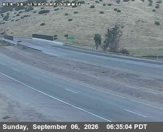 Verified · 5h updates ~every 5 min
 Tehachapi Summit weather & road conditions
- How do I check Tehachapi Summit road conditions?
- Check Tehachapi Summit road conditions with the live cameras on this page: 1 of 1 verified live in our latest checks. Each camera shows the pavement, weather, and traffic at its spot right now. It is a current image, not a text report or incident feed.
- Are these cameras live?
- We recheck every camera around the clock. A camera's badge shows when its feed last answered a check, and a feed that stops answering is marked offline. 1 of 1 are verified live in our latest checks.
- Is Tehachapi Summit closed right now?
- A camera is the fastest visual check, but closure calls are official ones: for closures, accident reports, and chain controls, see Caltrans road conditions. Caltrans road conditions
- What is the weather at Tehachapi Summit?
- The cameras double as Tehachapi Summit weather cams: each frame shows the sky and the road surface at its elevation right now. For a forecast, check the National Weather Service. NWS point forecast
More in California
- San Francisco Bay Bridge cameras
- Donner Pass cameras
- Golden Gate Bridge Approach cameras
- Cajon Pass cameras
- Caldecott Tunnel cameras
- Coronado Bridge cameras
- Echo Summit cameras
- Richmond-San Rafael Bridge cameras
- San Mateo Bridge cameras
- The Grapevine (Tejon Pass) cameras